|
Strand
I
Historical
Perspective
I.2.LE.2 Use narratives and graphic data to compare the past of
their local community, the state of Michigan, and other parts of the
United States with present day life in those places. DESK MAP Lesson
8.
Strand II
Geographic
Perspective
II.1.LE.2 Locate and describe diverse kinds of communities and
explain the reasons for their characteristics and locations.
DESK MAP Lessons, 7, 8, 12, 15, 36, 37.
II.1.LE.3 Locate and describe the major places, cultures, and
communities of the nation, and compare their characteristics. DESK
MAP Lessons 9, 12, 13, 23, 36, 37.
II.2.LE.2 Describe the location, use and importance of different
kinds of resources and explain how they are created and the
consequence of their use. DESK MAP Lesson 22.
II.2.LE.3 Describe the major physical patterns, ecosystems,
resources, and land uses of the state, region, and country, and
explain the processes that created them. DESK MAP Lessons 2, 4, 5,
18, 22, 26, 33.
II.2.LE.4 Explain how various people and cultures have adapted to
and modified the environment. DESK MAP Lessons 6, 7, 18, 22, 24, 26,
30, 31, 33.
II.3.LE.1 Describe major kinds of economic activity and explain the
factors influencing their location. DESK MAP Lessons 5, 6, 18, 22,
23, 24, 26, 32.
II.3.LE.3 Explain how transportation and communication link people
and communities. DESK MAP Lessons 17, 23, 24, 25, 26, 30.
II.3.LE.4 Describe some of the major movements of goods, people,
jobs, and information within Michigan and the United States and
explain the reasons for the movements. DESK MAP Lessons 6, 7, 14,
19, 20, 23, 26, 27, 32.
Strand
III
Civic
Perspective
III.1.LE.1 Distinguish among local, state, and national government
in the United States and describe the roles of government
institutions at all three levels. DESK MAP Lessons 5, 38.
III.1.LE.2 Give examples of authority and the use of power without
authority. Pages 111-113, 141, 271-274. T chapter 13 CDV activity,
“A Constitutional Principle Was Lost.”
III.4.LE.3 explain the basic organization of the local, state, and
federal governments. DESK MAP Lessons 38.
Strand IV
Economic
Perspective
IV.4.LE.3 Analyze how Michigan’s location has impacted its
economic development. DESK MAP Lessons 7, 15, 17, 22, 23.
Strand V
Inquiry
V.1.LE.3 Interpret social science information about local, state,
and national communities from maps, graphs, and charts. DESK MAP
Lesson 11.
Strand
VI
Public
Discourse and Decision Making
VI.1.LE.3 Evaluate possible resolutions of a public issue. DESK MAP
Lesson 35.
|


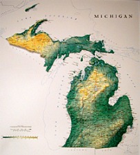 Michigan
Relief Map
Michigan
Relief Map